Italiano |
The flora of the
catchment basin of Rio Santa Lucia |
|||||||
![]()
Abstract
The flora of the catchment basin of Rio Santa Lucia (south-west Sardinia) has been studied, 669 taxa, 628 of which were species, 35 subspecies, 2 varieties and 4 hybrids were found. They were included in 364 genera and 101 families. The floristic richness indices have been determined and compared with those of other studied areas of Sulcis. An analysis of the biological spectrum showed the therophytes at 41.2% in confirmation of the full Mediterranean character of the area and the phanerophytes at 10%, showing the high degree of wooded cover. A comparison with the biological spectra of other floras shows similar values, except for a lower value for the therophytes and a significantly higher value (2.7%) for the hydrophytes. The chorologic spectrum shows dominance of Mediterranean elements (71.6%), particularly steno-Mediterranean (26%) and euri-Mediterranean (21.8%). The western-Mediterranean (3.5%), the southern-Mediterranean (3.5%) and the Atlantic-Mediterranean (3.1%) components are important in identifying the biogeographic barycentre of the studied area. The contingent of endemics (60 taxa) was 9% and shows dominance of Sardinian-Corsican (31.7%) and Sardinian (21.7%) elements, that together make up 53.4% of the total. 10 new entities which are endemic or with a particular phytogeografic interst for the mountain complex of Sulcis, have been lastly reported.
The floristic and vegetational studies of the past 15 years in Sulcis (Chiappini & al. 1983, Mossa 1985, Mossa & Fogu 1985, Angiolino & Chiappini 1988, Ballero 1990, Brullo 1993, Camarda & al. 1993, Ballero & al. 1994, Camarda & al. 1995, Mossa & al. 1996) have been concentrated mainly on the area of Punta Sebera-Punta Maxia-Pantaleo, Monte Tamara and Monte Arcosu. The valleys of Gutturu Mannu and Monti Nieddu have only been considered marginally, while little is known on the catchment basin of Rio Guttureddu and Sa Canna. The aim of this work is to complete the floristic knowledge of the hilly and mountain sections of the catchment basin of Rio Santa Lucia and to contribute further to the knowledge of the bioclimatic and chorological characteristics of the mountains of Sulcis.
Geographic framing
The hilly and mountain section of the catchmemt basin of Rio Santa Lucia (Fig. 1) is part of the mountain complex of Sulcis. It borders on the Campidano and Cixerri plain to the north, on the Rio San Gerolamo basin to the east, on the Rio di Pula basin to the south-east and south and on the Rio Palmas basin to the west.
It is included in the I.G.M.I. sections of Assemini (556, II), Capoterra (565, I) and Narcao (565, IV). From an administrative point of view, most of the area is under the communes of Assemini, Capoterra and Uta; only the Sa Mirra area is under the commune of Santadi.
The study area includes the entire hilly and mountain system and in particular the valleys of Gutturu Mannu, Guttureddu and Sa Canna. It has a perimeter of 54.2 Km and a total area of 72.9 Km2. The watershed passes through the mountains of S'Arcu de Is Sennoras (389 m), Punta su Aingiu Mannu (605 m), Monte Is Pauceris Mannu (726 m), Monte Mannu (716 m), Monte Sa Mirra (1086 m), Monte Is Caravius (1113 m), Monte Genna Strinta (856 m), Monte Arcosu (946 m), Punta s'Ala Matta (670 m) and Punta de Is Tuvaras (380 m).
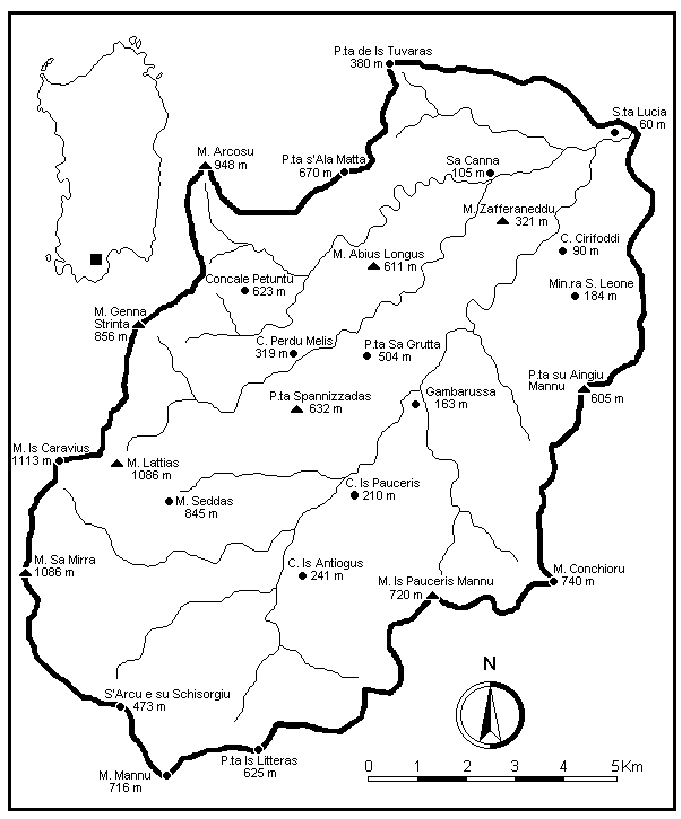
Fig. 1. Index map.
Geomorphology
The catchment basin of Rio Santa Lucia can be subdivided into three well-defined morphological structures: the prevalently schistose metamorphic landscapes, the granitic landscapes and the Quaternary alluvial deposits.
The mountain and hilly section is characterised by schistose (45%), granitic (52%) and calcareous (3%) reliefs. At the top, the schistose reliefs present relics of subhorizontal erosion surfaces or gentle slopes towards the west, as can be observed at Sa Sperrimas, Medau Spuntacora, Punta Stazzu Aroni, Monte Abius Longus and Is Crabiolus Mannu. Metamorphic rocks generally present quarts veins that resist erosion and create rough forms that give the landscape a tormented aspect with winding ridge lines and meandering watercourses, especially in the degrading areas from Is Pauceris Mannus to Punta de sa Loriga.
The granitic reliefs are characterised by two different morphologies. In places where the batholith is homogeneous, the granite presents soft rounded forms with mild slopes, while where it is more fractured, vein processes are present and rough irregular forms predominate as in the whole Monte Lattias area.
The calcareous areas are mainly characterised by the Cabitza formation (Lower Cambrian-Lower Ordovician). They are located in the westernmost and highest part of the basin and form an island in the granitic batholith.
Geology
Crystalline Palaeozoic substrates dominate the study area, and Quaternary clastic formations represented essentially by ancient and present alluvium and by alluvial glacis are found subordinately.
The Palaeozoic occupies about 90% of the area; the present formations underwent structural changes essentially for tectonic reasons and by thermo-metamorphism associated with the intrusion of granitic magmas during the Hercynian orogeny.
The age of the formations ranges from the lower Cambrian to the Silurian. The Cabitza formation is the oldest, and is found in the summit areas of Monte Seddas, Is Caravius and Sa Mirra. It is made up of clayey schists, metasandstones, nodular metalimestones and metasiltites with rare limestone lenses (Carmigniani 1996).
Overlying the granitic mass are two distinct tectonically superimposed successions (Barca & al. 1986): one is allochthonous (Arburese Unit) the other para-autochthonous (San Leone Unit). The Arburese Unit is made up of a sequence of mica metasandstones, clear metaquarzites with banks of metaconglomerates, metasiltstones and metapelites; it is very similar to the Genn'Argiolas Unit of south-eastern Sardinia (Barca & al. 1991). During the first phase of Hercynian orogeny, it was affected by regional folding with a main north-east/south-west direction on the parautochthonous terrains of the San Leone Unit. In the latter Unit, that is attributed to the Lower Ordovician - Silurian, we can observe three lithological series characterised by very few fossils due to the thermometamorphism induced by late Hercynian granitoids.
As regards the Hercynian magmatism, from a petrographical point of view the granites are classified as biotite leukogranites with a medium coarse equigranular structure (Conti 1963), and are characterised by the presence of rosy potassium feldspar (Bralia & al. 1981). They are rarely compact, and often affected by pegmatitic quartzose vein fractures and intrusions.
As regards the Quaternary, from a stratigraphic point of view we can recognise from bottom to top an older glacis probably of the Lower - Middle Pleistocene, terraced and heavily cemented, ancient dark reddish alluvium, a few conglomeratic deposits in the form of glacis, recent alluvium (Upper Pleistocene), loosely cemented fault rubble (Post-Wurm) and present alluvia with a pebbly-sandy matrix (Holocene) along the river beds.
Hydrography
Rio Santa Lucia rises in the Gutturu Mannu valley at a height of 575 m and after about 25 km flows into the Capoterra lagoon. Its drainage pattern includes 1,308 watersheds, for a total 526 Km. Its drainage density is 5.05 km/km2, its drainage frequency 12.55 km/km2 and its drainage coefficient 0.20 km/km2 (Fadda & Pala 1992). Its main tributaries are Rio Gutturu Mannu and Rio Guttureddu, that join at an place called Santa Lucia that gives the river its name. Among other watercourses, Rio Trunconi Mannu, Rio di Fanebas and Rio Sa Canna are worthy of mention.
Bioclimatology
The Rio Santa Lucia basin is the only catchment basin in the Sulcis mountains without a meterological station. An automised exchange has recently been installed at Gambarussa by the Forestry Authority of Sardinia.
For the bioclimatic characterisation of the site, reference was made to the data reported in Arrigoni (1968) and to those published by the National Hydrogaphic Service (Ministero LL. PP. - Ministry of Public Works - 1966-1980) for the neighbouring thermopluviometric stations of Is Cannoneris and Santadi.
As regards the methodology we followed the suggestions of Rivas-Martinez (1995). In spite of this, since no data were available on the minimum and maximum temperatures, it was not possible to process the normal (It) and compensated (Itc) thermicity indices. Since neither the data relating to the mean yearly or the summer evapotranspiration were available, it was not possible to calculate the aridity index (Iar), the yearly umbro-evaporation index (Ioe) and the Mediterraneity index (Im).
The bioclimates, the thermotypes and the umbrotypes were therefore calculated using the simple continentality index (Ic) and the umbrothermic index (Io).
According to the climatic data available and in agreement with the bioclimatic classification by Rivas-Mart�nez (op. cit.), it may be stated that the macrobioclimate of the studied area is of the Mediterranean type. In fact after the summer solstice it always presents a drought period (P<2T) longer than two months (Tab. 1).
Station |
Jan |
Feb |
Mar |
Apr |
May |
Jun |
Jul |
Aug |
Sep |
Oct |
Nov |
Dec |
Year |
Rainy days |
Is Cannoneris |
166.1 |
164.7 |
134.3 |
90.7 |
64.6 |
16.0 |
3.9 |
13.5 |
47.3 |
133.3 |
143.6 |
193.5 |
1172.0 |
89.6 |
Santadi |
93.0 |
77.3 |
64.9 |
42.8 |
36.3 |
10.8 |
3.8 |
10.9 |
33.2 |
77.9 |
98.6 |
111.7 |
657.0 |
68.4 |
Tab. 1. Mean monthly and annual rainfall.
As regards the bioclimates, from the simple continentality index and the umbrothermal index, it can be seen that both stations are within the oceanic pluvioseasonal bioclimate range since they present Ic values lower than 21 and Io values higher than 2.0 (tab. 2).
Station |
Jan |
Feb |
Mar |
Apr |
May |
Jun |
Jul |
Aug |
Sep |
Oct |
Nov |
Dec |
Year lymean |
Ic |
Io |
||
Is Cannoneris |
6.7 |
5.7 |
7.1 |
9.1 |
15.5 |
18.3 |
22.7 |
22.0 |
19.9 |
12.9 |
9.6 |
7.3 |
13.1 |
17.1 |
6.9 |
||
Santadi |
9.8 |
9.2 |
12.2 |
14.5 |
14.8 |
23.6 |
26.8 |
27.6 |
24.0 |
20.3 |
15.3 |
12.0 |
17.8 |
18.4 |
2.9 |
||
Tab. 2. Mean monthly and yearly temperatures, continentality index and umbrothermic index.
As regards thermotypes, since the data needed to calculate the compensated thermicity indices were not available, it was not possible to determine with certainty which are the thermotypes in Sulcis and in particular in the Rio Santa Lucia catchment basin. Based on the proposal by Rivas-Mart�nez (1982), using the mean yearly temperature values, we determined a meso-Mediterranean thermotype for the Is Cannoneris station (T=13.1�) and a thermo-Mediterranean thermotype for the Santadi station (T=17.8�).
From the above data and from a first analysis of the vegetation, we can hypothesise a thermo-Mediterranean plan only for those north-eastern areas of the basin below an altitude of 200 metres and a meso-Mediterranean thermotype for the area in general.
The umbrotypes were possible to calculate thanks to the umbrothermal index that showed a dry umbrotype (Io=2.9) for the Santadi station, verging on the subhumid limit (Io=3.0-6.0), and a humid one for Is Cannoneris (Io=6.9). Based on these data, we showed the presence of a subhumid umbrotype, that could not be determined directly but proved to be dominant on the basis of vegetation responses. In the basin, the presence of a number of mesophilic elements such as Taxus baccata L., Polystichum setiferum (Forssk.) T. Moore ex Woyn. and Blechnum spicant (L.) Roth, would confirm the existence of a humid umbrotype as for the Is Cannoneris area.
From pluviometric data, that were available also for the stations of Capoterra and Pantaleo, it is shown that rainfall tends to increase with increasing altitude and on moving from the coast to the flat areas inland from mountain massif (Tab. 3).
Station |
P (mm) |
Altitude (metres) |
Distance from the sea (Km) |
Distance from flat areas (Km) |
Capoterra |
552 |
54 |
5.3 |
0 |
Santadi |
657 |
135 |
12.4 |
0 |
Pantaleo |
888 |
240 |
18.6 |
7.1 |
Is Cannoneris |
1172 |
716 |
14.2 |
9.8 |
Tab. 3. Relation between annual mean rainfall, altitude and distances.
Vegetation
In the whole catchment basin, the vegetation was systematically cut until 1948. After that date, coppicing became more irregular, tapping of the cork oak trees was abandoned and trees are cut only in the Monte Arcosu natural reserve and along the roads inside the areas managed by the Forest Authority of the Sardinian Region.
As a result of the cuts that were practised up to the post-war period, of grazing and of fires, about 50% of the area today is made up of maquis attributed to Quercion ilicis Br.-Bl. 1936 em. Rivas-Mart�nez 1975 and Oleo-Ceratonion Br.-Bl. 1936 ex Guin. & Dron. 1944.
About 30% is made up of coppiced oak and cork oak woods. The latter do not cover more than 5% of the area and are concentrated in the Gutturu Mannu valley and in particular at Is Antiogus, Fanebas, Is Pauceris, Is Castangias and Gambarussa. At Guttureddu they are only found at Perdu Melis.
The topmost areas are more frequently covered by camephytic vegetation that can be framed in the Teucrion mari Gamisans & Muracciole 1984 alliance and by cespitose meadows that can be included in Periballio-Trifolion subterranei Rivas-Mart�nez, Fernandez Gonzales & Sanchez Mata 1986 (Ladero & al. 1992). On the tops of Mount Arcosu, Mount Genna Strinta and along the ridges that divide the valleys of Bacchialinu, Gutturu Mannu, Guttureddu, Sa Canna and Sa Spindula, most of the area is occupied by this camephytic vegetation.
On the alluvial terraces of the pebbly beds of the torrents, a similar camephytic vegetation is found. This vegetation was referred by Biondi & al. (1995) to the Glaucion flavi Br.-Bl. 1947 alliance. These formations are particularly frequent in the middle parts of the Rio Gutturu Mannu valley and in the low parts of the Rio Guttureddu valley. Terophytic meadows that can be included among the Maresion nanae Gehu & al. 1981 are frequent on the same alluvial mattresses.
The river beds are characterised by maquis that can be included in the Rubo-Nerion oleandri alliance Bol�s 1985 and in places where the water table is shallow or along the watercourses with a constant flow rate, they are characterised by riparian woods that can be included in the Hyperico hircini-Alnenion Dierschke 1975 sub-alliance or in Nerio oleandri-Salicion purpureae De Foucault 1991. The formations belonging to the latter alliance tend to dominate in the flatter areas where the sediments increase and the watercourses slow down.
The dripping rocks on the other hand present a vegetation that is traced back to the Adiantion Br.-Bl. 1931 alliance. The winding ravines and rocky walls with a cool exposure tend to have a silicicolous vegetation that can be framed in the Anomodonto-Polypodietalia serrati Bol�s & Vives in Bol�s 1957 order. Those with a warm exposure are colonised prevalently by casmophytic formations attributed to Phagnalo saxatilis-Cheilanthion maderensis Loisel. 1970 corr. P�rez-Carro, Diaz-Gonzales, Fernandez-Areces & Salvo 1989, while the weakly sloping rocky areas and the poorly evolved terrains present associations that can be reduced to the Micromerio graecae-Hyparrhenion podotrichae Bol�s 1962 corr. and Tuberarion guttatae Br.-Bl. 1931 alliances (Camarda & al. 1995). All the pioneer therophytic meadows belong to the latter alliance.
Flora
The floristic survey was carried out in successive stages between 1991 and 1997. During this period a number of excursions were made to study the different seasonal aspects and the different habitats of the area.
The list of flora was prepared following the systematic order and nomenclature proposed by Pignatti (1982), except in a few cases where we preferred to follow Arrigoni & al. (1976-91), Castroviejo & al. (1986-1997), De Bol�s & Vigo (1984-1997), De Bol�s & al. (1990), Ferrarini & al. (1986), Greuter & al. (1984-1989), Jalas & Suominen (1972-1996), Pichi Sermolli (1977), Tutin & al. (1964-1980) and Scrugli (1990).
The attribution of the biological forms and subforms were made following the criteria proposed by Braun-Blanquet (1932), Raunkier (1934) and Pichi Sermolli (1948), and the forms of the diffferent taxa were checked directly in the field. Besides the biological form, for each individual entity the list shows the chorology, according to the types reported in Pignatti (op. cit.), Castroviejo & al. (op. cit.), De Bol�s & Vigo (op. cit.), De Bol�s & al. (op. cit.), Greuter & al. (op. cit.), brief indications on the habitat or place they were found, and on their frequency in the territory. As regards frequency a scale with the following abbreviations was used (cc= very common, c= common, pc= not common, r= rare, rr= very rare, n.s.= not specified). The entities reported in the literature but not found in the field are indicated with an asterisk (*), for those species whose exist specimen, informations about it are provided.
As regards adventitious and cultivated species, we only reported the naturalised entities.
The specimens are deposited at the Herbaria of the Department of Botanical Sciences of the University of Cagliari (CAG) and the Botanical Department of University of Catania (CAT) and the Botanical Garden of Valencia (VAL).
![]()
